

Research
Cross-Data Analysis Technology
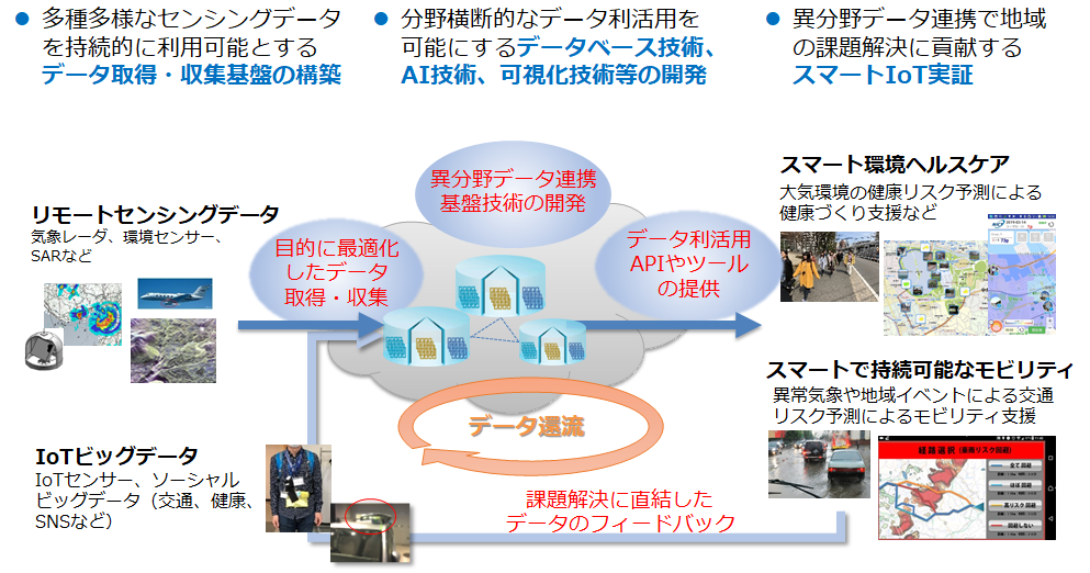
For the purpose of accelerating the use of data in the era of Society 5.0, we will make efforts to develop a cross-data analytis technology for utilizing data obtained from a variety of sensing technologies and different kinds of social big data to construct a platform that will help develop and expand smart services with a view towards a sustainable society, and will conduct activities for accelerating open innovation using regional IoT platforms.
Data Mining for Heterogeneous Sensing Data
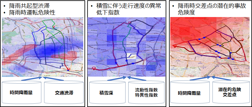
We are developing data mining technology for collecting and integrating sensing data accumulated at multiple data sources on demand for analyzing their association. It includes an integrated method of spatio-temporal clustering and association rule discovery for finding locally-associative datasets, an algorithm for faster processing of association rule mining in rare cases such as accidents and disasters, and an efficient method for high-utility frequent itemset mining. These technologies are applied, for example, to predict a risk of traffic disruptions such as accidents and congestion in the event of heavy rain, heavy snow or other abnormal weather conditions based on past cases.
AI-Based Environmental Quality Prediction Technology
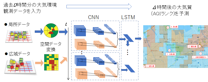
We are developing prediction technology for meteorological, atmospheric and other environmental data based on the Convolutional Recurrent Neural Network (CRNN), which integrates spatial pattern learning by the Convolutional Neural Network (CNN) with temporal pattern learning by the Long Short Term Memory (LSTM). This technology is applied, for example, to short-term prediction of air quality index affected by trans-border air pollution. In this technology, we have sought an optimal method of integration between the CNN and the LSTM in consideration of the spatio-temporal continuity of environmental data to achieve high levels of versatility and prediction accuracy. We also endeavor to develop technology for optimizing prediction in collaboration between a variety of observation data and application-specific data collected from users.
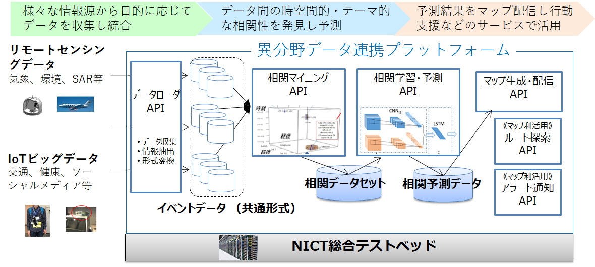
xData(cross-data) Platform
We are constructing on NICT’s Integrated Testbed a platform implementing functions of a data loader for data collection, retrieval and conversion from a variety of data sources, association mining for spatio-temporal data integration and discovery of association rules, machine learning for prediction of spatio-temporal association patterns, and creation and distribution of GIS data from prediction results for route search and alert notification.
[Example of Application] Safe route navigation with the use of environmental and traffic data
Association mining from a variety of meteorological and traffic data is performed to create and distribute a map that predicts various transport disturbance risks due to heavy rain, heavy snow and other abnormal weather conditions and to search for safe, risk-free routes.
With a view to invent a smart automotive navigation app that responds to traffic risks arising from natural disasters, regional events and other sudden environmental changes, a hackathon is conducted in a development environment that supports the customization of navigation screen displays and route changes while taking advantage of risk prediction maps and route searches.
- Related Topic
- Smart Sustainable Mobility Hackathon
(Feb. 23-24, 2019)
[Example of Application] Fitness support with the use of environmental and health data
Different activities are conducted with the aim of developing smart services that convert local climatic, atmospheric, natural and other environmental resources into health resources to help promote people’s health and create health businesses in the region. One example is drawing digital maps of association between the atmospheric environment and health by combining data on personal exposure to the atmospheric environment collected with small sensors, health data such as volume of physical activity and autonomic balance, short-term AQI prediction based on CRNN on the platform. Another is a trial joined by users for health promotion through walking and the collection of environmental data after the development of a trial system that scores the amount of physical activity while walking and the air quality level.
- Related Topic
- Datathon in Search for Healthy Air
(First: Mar. 10, 2018 - Apr. 8, 2018, Second: Mar. 23-24, 2019/Apr. 6-7, 2019)